Точная многоуровневая инспекция посевов с использованием спутников, дронов, смартфонов и технологий машинного обучения — для оценки состояния культур, выявления проблем защиты и планирования мероприятий.
Назначение
Многоуровневая инспекция посевов с помощью спутников, дронов, смартфонов и ML для оценки состояния культур и планирования действий.
Целевые сегменты
Агропредприятия и кооперативы фермеров
Производители и дистрибьюторы семян, средств защиты и удобрений
Интегрированные продовольственные компании
Система позволяет
Эффективный сбор данных о полях через спутники, дроны и смартфоны
Коллективная корпоративная работа с консолидацией внешних данных
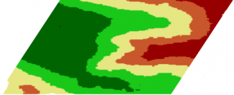
Выявление зон вариативности, повреждений и сорняков
Полевые испытания, оценка плотности растений, дифференцированное внесение
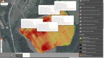
Спутники
Ежедневный мониторинг полей с разрешением 3 метра
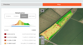
Ежедневные спутниковые снимки с разрешением 3 метра и несколькими вегетационными индексами (NDVI, LAI, EVI, NDWI). Исторические данные доступны. Сервис работает по всему миру.
Monitoring of fields daily by delivering 3-meter resolution satellite imageries (including historical data). Аналитика of the studied field with several vegetation indices (NDVI, LAI, EVI, NDWI, etc. based on four bands). Service is available worldwide.Historical analysis of the vegetation indices. Navigation through the history of vegetation indices, maps collected from drones, and even smartphones allow you to get a complete picture of your assets.Explore index histogram, dynamic recalculation of range. Manage by analytics details: 3, 5, 9, 256 colors. Dynamic calculation of the area of each differential zone. Export differential zones to KML and shapefile formats for variable rate applications.
Дроны для съёмки
Изучение зон риска с помощью простых в управлении дронов
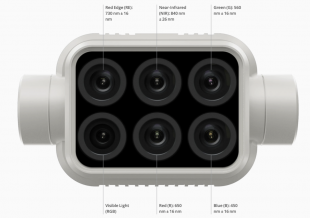
Анализ посевов с разрешением до 2 см/пиксель по ортофотоплану. Приложение Aeroscouter автоматизирует маршруты полётов. Совместимость с любым дроном (фото с GPS-тегами). Мультиспектральные индексы: NDVI, VARI, GNDVI, NDWI, SAVI, NDRE.
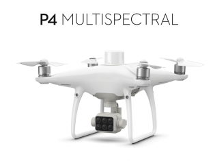
Drones allow analyzing crops in resolution up to 2cm per pixel by orthophoto map of fields.Mobile application for drone control – Aeroscouter – enormously simplifies data collection for non-professional pilots. . The whole process of data collection is fully automated. . Users can set field boundaries in advance in the cloud application. Aeroscouter builds the flight route over the field. . You just press the button “Start” in the Airscouter, and the drone takes off, runs the survey by the route, and lands automatically.An orthophoto is a crop canopy map assembled from drone images into orthogonal projection. . The process of orthophoto building is fully automatic. . Despite the significant processing capacity required for the production of such maps, you just need to download the drone photos in our cloud and launch the process to get ready-to-analyze orthophoto map.Our system is drone agnostic. There is only one requirement for photos: it should be GPS tagged. . But we recommend DJI Multispectral P4 for surveying fields and obtaining a wide range of vegetation indices. . Technical Specifications: -Maximum flight time: 27 minutes-Maximum coverage area at an altitude of 180m and a resolution of 10 cm per pixel per flight: 63 hectares-Five multispectral channel cameras: Blue, Green, Red Edge, Near-infrared-10 cm vertical and horizontal accuracy .Compact multispectral cameras allow you to build a wide range of vegetation indices, including NDVI, VARI, GNDVI, NDWI, SAVI, NDRE, etc. . .It is possible to generate pseudo-vegetation indices even with a visual camera: pseudo-NDVI, VARI, and so on.
Полевые исследования
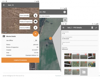
Groundscouter — ваш смартфон как профессиональный инструмент
Задание точек инспекции (POI) в облаке для приложения на смартфоне
Сбор изображений и показателей офлайн с последующей синхронизацией
Построение карт интерполяции по собранным полевым данным
Set Points of Inspection (POIs) in a cloud application for further use ones in smartphone applicationGroundscouter allows you to collect images and preset indicators by POIs . Offline mode: the ability to collect data in a field without Internet coverage with further synchronization of information with the cloudBuilding of interpolation maps based on the collected indicators at POIs
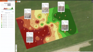
Аналитика
Продвинутая аналитика — от сегментации до плотности посевов
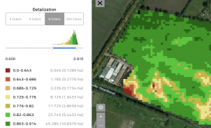
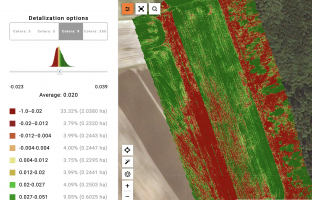
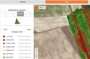
Анализ мультиспектральных индексов: Гистограмма, аналитика 3/5/9/256 цветов, динамический расчёт площади зон.
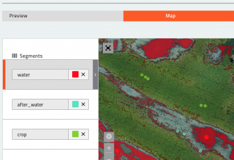
Сегментация: Интерактивное зонирование на визуальных картах по цвету и структуре.
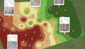
Интерполяция: Карты по данным Groundscouter, фото дронов и анализу почвы.
Карты плотности посевов: Карты на основе ML по фото дронов; разведка зон по уровню роста.
Корреляционный анализ: Изучение корреляции между полевыми показателями и вегетационными картами.
Аналитика of multispectral indices . Index histogram, range recalculation. Analytics detail: 3, 5, 9, 256 colors. Dynamic calculation of the area of each differential zone.Сегментация. An interactive segmentation tool that allows you to quickly highlight the differential zones, even on a visual map, considers the color characteristics of crops and structure.Интерполяция. Building of interpolation maps based on: -parameters collected at points using the Groundscouter mobile application.-Interpretation of detailed photos from drones.-Chemical analysis of soil, etc. .Карты плотности посевов. Build crop density maps using detailed photos collected from the drone and Machine Learning. Use crop density map to scout areas with different levels of growth. . .Correlation Аналитика. Study of the correlation of indicators collected in the field with vegetative satellite maps.
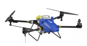
Дроны-опрыскиватели
Переменное опрыскивание на основе данных дистанционного зондирования
Spraying drones reduce pesticide use by 30% and water waste by 90%. Variable spraying targets only zones requiring protection — not the whole field.
Использование спутниковых, дроновых, сегментационных или интерполяционных карт для обнаружения зон вариативности
Создание задач дифференцированного внесения и генерация карт-предписаний (KML / shapefiles)
Use any type of maps (satellite and drone vegetation maps, segmentation, interpolation maps) and their combination to detect variability zones.Build Tasks for differential application of inputs from drones. Prescription map can be generated using any type of maps in the system or their combination in the form of KML or shapefiles
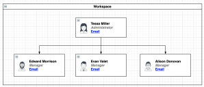
Операции
Cloud-Based Corporate Операции
Корпоративная облачная система, реализующая все бизнес-процессы: планирование операций, сбор данных и анализ Больших Данных в масштабах корпорации.
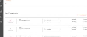
Многоорганизационная структура с изолированными рабочими пространствами и индивидуальными правами доступа
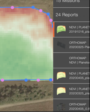
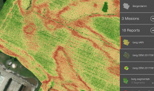
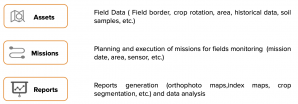
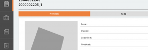
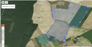
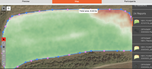
Реестр активов: поля с названием, адресом, площадью, севооборотом и границами
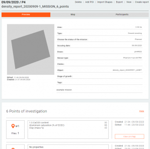
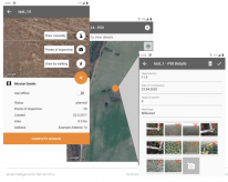
Миссии: задачи, привязанные к активам с датами, пилотом, моделью дрона и статусом
Отчёты: мультиспектральные карты, сегментация, аналитика плотности растений
Multi-org structure. Entities, data, and users of the system are logically organized into workspaces. Users in the workspace are logically isolated from users and data in other workspaces.Access to each entity in the system can be limited to a specific list of users with individual rights.Simple hierarchy of entities and data in the system, which allows you to structure and analyze data easily and effectively.Assets allow to maintain a register of fields with their main properties: name, address, area, crop rotation, boundaries, etc. Field boundaries can be drawn either manually or imported from shape or KML.A Mission is a monitoring/inspection task.. The mission is linked to the Asset. For each Asset, you can create as many inspection Missions as you want.. The Mission contains information about the planned and actual date of the inspection, the pilot and the drone; mission status; data collected during the inspection.. The type of Mission can be Ground, Aerial, or Satellite.Reports contain primary data processing results and analytics, such as multispectral maps, maps of segmentation, plant density, etc.
Преимущества для бизнеса
Кастомизация
Каждая компания имеет уникальные бизнес-процессы и требования к отчётности. Наш отдел разработки кастомизирует стандартное решение, настраивает новые отчёты и адаптирует рабочие процессы под ваши требования.
Интеграция
Открытый API позволяет вашим специалистам или нашим разработчикам без проблем интегрировать платформу с вашими внутренними информационными системами — ERP, CRM и другими инструментами.
Премиум-поддержка
Несколько каналов связи для достижения наилучшего результата: электронная почта, веб-портал, Telegram-канал и голосовая поддержка — с выделенным аккаунт-менеджером для корпоративных клиентов.
Как это работает
Пятиэтапный рабочий процесс инспекции полей
Импорт или рисование границ полей в облаке
Получение регулярных спутниковых карт вегетации
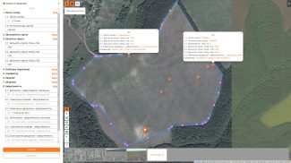
Запуск автоматизированных дроновых миссий на основе спутниковых данных
Разведка полей по точкам POI через мобильное приложение Ground Scouter
Загрузка данных в облако и проведение полного анализа
Create boundaries of your fields or import them into the System from electronic formatRegularly or upon request receive vegetation maps of fields from satellitesCreate drone survey missions based on vegetation satellite maps or autonomously . Collect data using drones .Simultaneously survey your fields by Points of Inspection using the Ground Scouter mobile appUpload your data to the cloud and perform analysis